12d Model GIS
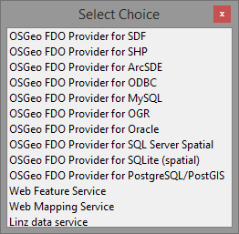
This module provides an interface between 12d® Model™ and other spatial information systems such as GIS and Web Mapping utilities through the use of open source FDO (Feature Data Object) technology.
- ArcSDE
- ArcGIS and ArcGIS Server
- MySQL
- OGR
- Oracle
- SQL
- WMS (Web Mapping Service)
- WFS (Web Feature Service)
Data from within 12d® Model™ can be directly added to the connected spatial information server or database removing the need for output files to be created to share the data.